
The Interspect Ltd. primarily produces aerial ortho image maps by RGB, MS or HS remote sensing and develops airborne instruments.
Aerial Surveys and Photogrammetry
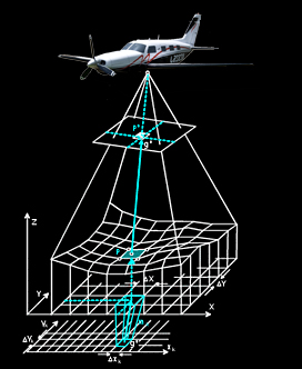
The digital aerial maps (ortho image mosaics) are created as a result of a special processing of perpendicular camera axis aerial images. These mosaics have both the advantages of geometrically exact map and detailed image. The ortho image mosaics document the condition of the surface at a given time that can be evaluated by several methods and analysis aspects. By archiving, they constitute a basis for comparison and they are available for analytical considerations and applications arise in the future. . Repeated aerial surveys allow comparisons of the legal status, the change monitoring and the cadastre of buildings, mining, lakes and green areas. If required, the evaluation of image maps (the information content) may be presented in thematic maps.
Orthophoto mosaics
We produce aerial ortho image mosaics of 0.5 - 100 cm spatial resolution by fix-wing manned aircraft. The used unique technology allows making raster layers for GIS databases with high image-quality. Due to the three-dimensional photogrammetric processing, all images become accurate orthophotos with coordinates.
Aerial Surveys
After the planning and licensing, among appropriate weather conditions, the precision flight can be conducted. The deviation from the planned flight line is in average 5 meters. Several factors determine the image-quality, but the remotely sensed images we produce meet the highest requirements.
The details of the process

- Assessing the User needs
- Mission Planning
- Authorization
- Aerial survey with direct georeferencing
- Refinement & control geodetic survey
- Image processing (ortho-rectification and mosaicking)
- The projection, the file format and the tiling are chosen by the customer
- Evaluation and online GIS (if required)
Image Interpretation and Database Construction
- Evaluation of remotely sensed images
- Database construction
- Expertise